Current update
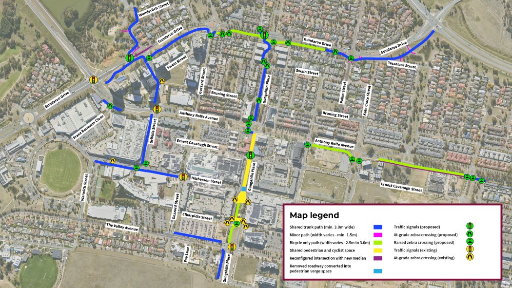
Detailed design is complete for eight paths in the Gungahlin Town Centre. You can find a plan showing the paths below. Construction of these eight paths is subject to future funding.
Page last reviewed 15 Jun 2026
Project description
Design is underway on Gungahlin Town Centre improvements.
Walking, cycling and other forms of active travel are at the centre of the ACT Government’s plans to make Canberra an even more liveable and sustainable city.
A number of projects are underway to improve opportunities for active travel as well as road safety and access in the Gungahlin Town Centre.
Active travel
In 2022 a feasibility study (PDF 22.2 MB) was completed looking at the availability of active travel in the Gungahlin Town Centre. It also identified possible improvements to the active travel network. More information about the findings of the feasibility study is included below.
The feasibility study identified 12 individual community paths (PDF 5.4 MB) to improve active travel in the Gungahlin Town Centre.
Concept designs were initially developed for 11 of those community paths.
An additional two sites were added to the list and have also had designs developed.
In the 2023-24 ACT Budget, funding was provided to progress high priority segments through to detailed design. Detailed design work is now complete for eight of the 13 paths. You can view the design 199.7 KB. Construction of these paths is subject to future ending.
Location and link | Proposed improvements* |
|---|
Gundaroo Drive between Anthony Rolfe Avenue and Horse Park Drive Link 1 concept design (PDF 15.8 MB) | Provide a path link between Anthony Rolfe Avenue and Horse Park Drive. This includes priority crossings and two intersection upgrades to support active travel and improve safety. |
Gribble Street and Wunderlich Crescent at their intersections with Gundaroo Drive Link 2 concept design (PDF 3.8 MB) | Provide a path link along Gribble Street and Wunderlich Crescent to Yerrabi Pond District Park. This includes a signalised crossing and an intersection upgrade to support active travel. |
The Valley Avenue between Gungahlin Drive and Gungahlin Place Link 3 concept design (PDF 6.6 MB) | New and upgraded paths between Warwick Street and Gungahlin Place. This includes priority crossings. |
Anthony Rolfe Avenue between Franz Bormann Close and Hamer Street Link 4 concept design (PDF 9.7 MB) | New and upgraded paths including sections of shared and cyclist/pedestrian only paths and priority crossings to support active travel. |
The Valley Avenue and Delma View Link 5 concept design (PDF 8.8 MB) | Proposal to designate Delma View as an active street. Includes new and upgraded path connections as well as priority crossings. |
Gungahlin Place from Camilleri Way to Anthony Rolfe Avenue Link 6 concept design (PDF 6.8 MB) | New and upgraded paths including sections of shared and cyclist/pedestrian only paths. Includes a proposed intersection upgrades to support active travel. |
Gozzard Street between The Valley Avenue and Anthony Rolfe Avenue Link 7 concept design (PDF 5.4 MB) | Upgrades to the verge between The Valley Avenue and Anthony Rolfe Avenue. This could include widening, de-cluttering and paving. |
Gungahlin Town Centre to Yerrabi Pond Link 8 concept design (PDF 9.5 MB) | Provide a path from the Gungahlin Town Centre to the Yerrabi Pond District Park. This includes priority crossings and intersection upgrades to support active travel. |
Cantamessa Avenue (full length) Link 9 concept design (PDF 4.0 MB) | New priority crossings. |
Hollingsworth Street from Strayleaf Crescent to Gundaroo Drive Link 10 concept design (PDF 3.2 MB) | Replacement of existing path infrastructure and associated intersection improvements. |
Manning Clark Crescent from Camilleri Way to Marie Pitt Street Link 11 concept design (PDF 5.0 MB) | Replacement of existing path infrastructure. |
Gungahlin Area Transport Plan (ATP)
In addition to active travel improvements, the 2023-24 ACT Budget also allocated funding to develop a transport plan for Gungahlin.
A transport plan technical report was completed in early 2025, focussing on priority areas and corridors within the Gungahlin Town Centre and surrounds, and considered various modes of transport such as private vehicles, public transport and active travel. The report is being used to inform project selection and as a reference document for development and update of planning documents.
Gungahlin Corridor Transport Plan (CTP)
The 2024-25 and 2025-26 ACT Budgets allocated further funding to progress the next stage of Gungahlin road improvements in the form of a Corridor Transport Plan. This plan will expand on the previous Gungahlin Area Transport Plan to identify future infrastructure needs for all road users by focusing on the key transport corridors of Gungahlin Drive, Gundaroo Drive and Mirrabei Drive.
This work commenced in early 2026.
Intersection studies
The 2023-24 ACT Budget allocated funding to progress feasibility and design work for three intersections in the Gungahlin Town Centre. The purpose of this work is to improve road, cyclist and pedestrian safety.
ACT’s population is fast growing and many existing intersections were originally designed and constructed to operate at lower traffic volumes than what they are now experiencing. Improvements for these intersections may include the installation of traffic lights, reduced speed limits and traffic calming.
The three areas identified as part of this program of works are:
- Hinder Street/Efkarpidis Street (preliminary sketch plans)
- Hinder Street/Ernest Cavanagh Street (preliminary sketch plans)
- Anthony Rolfe Avenue from Gungahlin Place to Manning Clark Crescent (feasibility study).
In addition to the above, included in this program is also the intersection of the Barton Highway and Victoria Street in Hall where a feasibility study will be undertaken. This work is now underway.
