Garden City Cycleway


Current update

Construction of Stage 1 of the Garden City Cycleway is almost complete. Stages 1A, 1B and 1C are done, leaving just Stage 1D to complete for this section of the cycleway.

Design work and construction planning continues for the final section of Stage 1 (Stage 1D) which will run along Cooyong Street from Torrens Street to the Lonsdale Street traffic lights. The Garden City Cycleway will terminates at the intersection of Lonsdale and Cooyong Streets where users can safely cross Cooyong Street and connect to the Bunda Street shared zone. The City Renewal Authority is progressing the design of upgrades to Cooyong Street. This work will refer to the design work undertaken by the Garden City Cycleway design team.

Further updates about construction will be provided on this page. To view the individual stages, see the map below.

Page last reviewed 23 Sep 2025

Project description

Construction is underway on Garden City Cycleway.

Walking, cycling and scooting are at the centre of our plans to make Canberra an even more liveable and sustainable city. The Garden City Cycleway will provide a safe cycle route connecting Watson, Downer, Hackett, Dickson, Ainslie and Braddon with the city.

Using a variety of streets and places, the route will accommodate both cyclists on local trips and visitors exploring the city. The Garden City Cycleway will use existing streets to link Watson, Downer, Hackett, Dickson, Ainslie and Braddon before connecting to the City and lake edge via the inner-city cycle loop on Bunda and Allara streets. The route will connect schools, local centres and green spaces.

View the route alignment (JPG 187.6 KB)

Design treatments

The Garden City Cycleway includes sections of 3- and 4-metre-wide walking and cycling (shared) path.

The path travels through sections of open space and green space to better connect key locations in the surrounding suburbs and trial the ACT's first Active Travel Street. Learn more about the Active Travel Street Trial project.

Some sections of the designs remain subject to further investigations due to existing site constraints.

Active Travel Streets

Active Travel Streets create a safe environment for cyclists, scooters and vehicles to all use the road together.

They may include:

  • changes to the shape of the road to slow vehicles down
  • changes to traffic priority at intersections
  • changes to speed limits
  • raised concrete areas or pavement treatments at the entry to a street to signal a change in street environment (e.g. raised crossings and speed cushions)
  • concrete islands or pavement treatments to create short one-lane sections to encourage a slow speed shared environment
  • landscaping, lighting and other features to create a more welcoming environment for all types of travel
  • signage or design features on the road to indicate that it is a shared environment with priority for cyclists and pedestrians.

Preliminary design (indicative only)

View the preliminary sketch plans (PDF 30.5 MB) for all 7 routes which include:

  • Segment 1: Cooyong Street
  • Segment 2: Torrens Street - Cooyong Street to Ijong Street (complete)
  • Segment 3: Ijong Street - Torrens Street to Angas Street/Limestone Avenue intersection (complete)
  • Segment 4: Angas Street – Limestone Avenue to Majura Avenue via Ainslie Oval (complete)
  • Segment 5: Majura Avenue – Ainslie Oval to Hawdon Street
  • Segment 6(a): Majura Avenue/Phillip Avenue
  • Segment 6(b): Majura Avenue/Hawdon Place/Frencham Street/Bradfield Street/Windeyer Street
  • Segment 7: Knox Street to Antill Street via Simpson Street playground and Aspinall Street

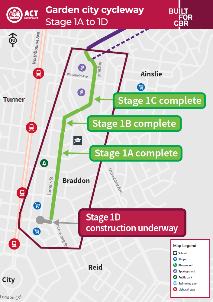
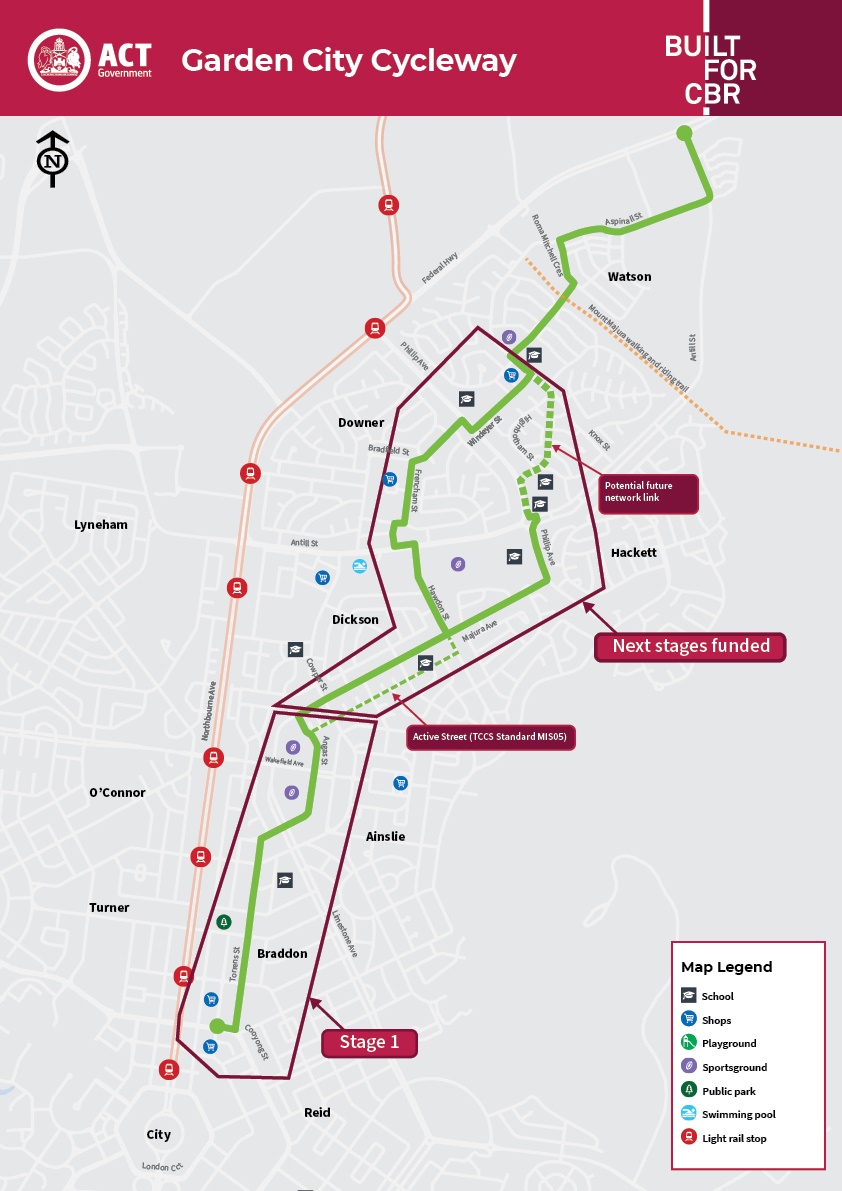
Construction: Stage 1

In the 2023-24 ACT Budget, the ACT Government matched the $5 million committed by the Australian Government for detailed design and construction of the first stage of the Garden City Cycleway.

Stage 1 includes segments 1 to 4 identified in the preliminary design:

  • 1A. Torrens Street between Cooyong Street and Ipima Street
  • 1B. Torrens Street from Ipima Street to Ijong Street and along Ijong Street to Limestone Avenue
  • 1C. Angas Street between Limestone Avenue and Majura Avenue
  • 1D. Cooyong Street between Torrens Street and Lonsdale Street.

1A (complete): Torrens Street between Cooyong Street and Ipima Street

This was the first part of the cycleway constructed. It includes a new 4-metre-wide concrete and asphalt walking and cycling path in the eastern verge of Torrens Street, from Cooyong Street to Henty Street and a new 3-metre-wide path continues from Henty Street to Ijong Street in Braddon.

In addition, 6 new raised asphalt zebra crossings were constructed along the cycleway at the crossing points on Torrens Street (near Cooyong Street), Elouera Street, Girrahween Street, Henty Street, Helemon Street and Ipima Street.

You can take a look at the detailed drawing (PDF 3.6 MB).

1B (complete): Torrens Street from Ipima Street to Ijong Street and along Ijong Street to Limestone Avenue

This was the second part of the cycleway constructed. It includes a new 3-metre-wide asphalt walking and cycling path in the eastern verge of Torrens Street and Ijong Street.

New traffic lights were installed at the Limestone Avenue, Ijong Street and Angas Street intersection.

You can take a look at the detailed drawing (PDF 1.8 MB)

1C (complete): Angas Street from Limestone Avenue to Majura Avenue

This was the third part of the cycleway constructed. It includes a new 3-metre-wide asphalt walking and cycling path in the eastern verge at the start of Angas Street then crossing to the western verge and continuing to Majura Avenue.

In addition, 4 raised concrete zebra crossings have been constructed along the cycleway at the crossing points on Angas Street, Wakefield Avenue and at the Ainslie district playing fields car park entry and exit.

You can take a look at the detailed drawing (PDF 7.1 MB).

1D (design underway): Cooyong Street between Torrens Street and Lonsdale Street

This is the fourth part of the cycleway planned to be constructed. Further details about the alignment and path will be provided here once known.

The Garden City Cycleway terminates at the intersection of Lonsdale Street and Cooyong Street where users can safely cross Cooyong Street and connect to the Bunda Street shared zone. The City Renewal Authority is progressing the design of upgrades to Cooyong Street. This work will refer to the design work undertaken by the Garden City Cycleway design team.

Reminder for drivers, cyclists and pedestrians

Changed road and pedestrian arrangements will extend along the cycleway as new parts of the route are opened to the community.

There are several things people should do to improve safety, particularly as everyone gets used to the new arrangements. Please see the important information below.

Reminder for drivers

You must give way to path users when exiting/entering driveways.

Assume path users will be present, look both ways before exiting and entering driveways.

Follow the speed limit and go slow when exiting/entering driveways. Children may be harder to see and not be as aware of their surroundings.

Reminder for cyclists and pedestrians

Make yourself visible, particularly at night, by using lights or clothing that is bright or has reflective material.

Ride with caution. Make eye contact with drivers to be sure they’ve seen you.

Give way to pedestrians, ring your bell and give plenty of room when passing.

Be mindful of the number of driveway crossings and the potential motorists do not see you. Ride to the conditions.

Frequently asked questions

The City and Gateway Urban Design Framework proposed a route for the Garden City Cycleway. The below table sets out the differences between it and the now preferred route.

Change

Reasoning

Use of Aspinall Street and Roma Mitchell Crescent rather than Negus Crescent and Ada Evans Street

The road reserve width on Negus Crescent and Ada Evans Street limits the ability to provide a suitable facility. There are also increased access locations and roadside activity that increase conflict points. The use of Aspinall Street and Roma Mitchell Crescent addresses these elements.

Alternative route to Cowper Street and Bonney Street

Bonney Street has multiple access points in comparison with alternative alignments.

Use of Torrens Street rather than Lonsdale Street

Commercial activity (pedestrians and vehicles) along Lonsdale Street, including parking demand, would impact the ability to provide an unimpeded facility. Connecting paths can be provided in the future.

The City and Gateway Urban Design Framework (December 2018) identified a preliminary alignment for the Garden City Cycleway. This alignment was further investigated by the ACT Government to understand potential cycling routes between Watson and the City.

A feasibility study was undertaken to review the previously identified route alignments and consider the constraints and opportunities present along the route to ultimately determine an achievable route. A preliminary design has now been completed to confirm the preferred route, propose intersection treatments and consider urban design and landscape elements to ensure careful consideration of all elements of the proposed route.

During the feasibility study and preliminary design stage, several consultation sessions were held with key stakeholders and information was gathered through a series of route alignment rides, workshops and presentations to the residents group. Stakeholders included representatives from advocacy groups and inner north community groups.

Broader engagement was undertaken with the community following the release of the preliminary designs in October 2023. Two pop-up information sessions were held and a ride along was held on Saturday 11 November 2023 in partnership with Pedal Power.

The cycleway will be shared by cyclists and pedestrians. In high activity and conflict areas, separation will be provided if considered necessary and practicable within site constraints.

The proposed path is to be constructed in a developed urban environment and consequently there are many physical constraints that restrict the width of path to the minimum recommended. These constraints include verge widths, driveways, trees, and services infrastructure such as streetlight and power poles. Three metre paths will still provide plenty of room to allow people to share the space.

The paths will be constructed of asphalt where possible but may be obliged to be concrete in areas for reasons of urban design, ground conditions or tree root management.

The ACT Government has completed preliminary designs for the full Garden City Cycleway from the City through to Watson.

In the 2023-24 ACT Budget, the first stage of works from the City to Ainslie was funded for detailed design and construction over 3 years.

In March 2025, the ACT and Australian Government announced joint funding to deliver Stage 2 of the cycleway between North Ainslie Primary School and Majura Primary School via:

  • the Dickson District playing fields
  • Downer shops
  • Academy of Interactive Entertainment
  • Majura Primary School.

This will see the cycleway connect the Inner North through suburbs, local shops and schools.

Ahead of construction, letterbox drops will be carried out to those residents and businesses located along the route. There will be an opportunity to meet with the project team on site to understand what the alignment is and how it interacts with your property and what temporary changes there may be for property access during construction.

The Active Travel Plan proposes a vision of more people walking and cycling more often and identifies priorities for strengthening active travel and improving quality of life. The Garden City Cycleway addresses many of these priorities including through the provision of safe infrastructure for walking and cycling, providing a network for walking and cycling that is better connected and making active travel easier.

The Design Guide provides guidance and examples to help practitioners aspire to best practice design of urban intersections and streets to support all transport including active travel infrastructure.

The Garden City Cycleway project aspires to best practice and will be guided by the current infrastructure standards and documents and will implement Safety in Design assessments to achieve safe and functional outcomes.

Maps

Click on the image below to view maps.

Map showing the Garden city cycleway through Ainslie and Braddon.

Stay updated

If you’d like to stay updated on this project, bookmark this page or email us at communityengagement@act.gov.au to be included on any project updates.